
Hurricane Season in Puerto Rico | Impact, SSTs, Location
As the summer sun dips below the horizon and the air begins to carry a hint of salt and humidity, Puerto Rico braces itself for a natural drama that unfolds with relentless regularity: hurricane season. Each year, from June to November, this Caribbean paradise transforms into both a breathtaking landscape of resilience and a stage for some of nature’s most powerful forces.
The vibrant streets of San Juan may bustle with tourists sampling mofongo and dancing salsa, but just beyond the palm-fringed coastlines lies an ever-looming threat hurricanes that can turn idyllic days into harrowing nights in mere moments.
Join us on this journey through the heart and soul of hurricane season in Puerto Rico, a tale woven with courage, legacy, and unyielding determination.
The Predictability and Impact of Hurricane in Puerto Rico
Hurricane season in Puerto Rico, aligning with the broader Atlantic hurricane schedule from June 1st to November 30th, brings a blend of predictability and uncertainty.
Historical Impact
Hurricane Okeechobee in 1928 and Hurricane San Ciprian in 1932 marked pivotal moments in Puerto Rico’s struggle against natural disasters, laying bare the island’s vulnerability to extreme weather events.
The cataclysmic damage from these early hurricanes set a precedent that would resonate through history, showcasing not just physical destruction but also a socioeconomic impact that lasted for decades.
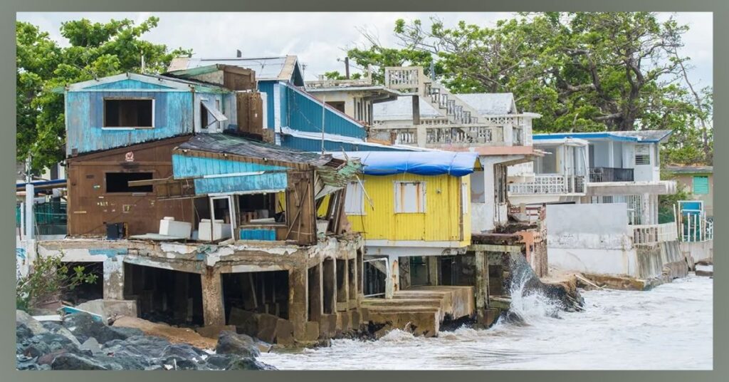
Fast forward to 2017, when Hurricanes Irma and Maria unleashed catastrophic winds and flooding that devastated infrastructure, disrupted essential services, and displaced thousands of residents, their aftermath vividly illustrated the repercussions of unpreparedness in an era increasingly informed by climate change.
Frequency
On average, Puerto Rico experiences around four tropical storms or hurricanes each year, making its residents acutely aware of the impacts these powerful natural phenomena can have.
The Caribbean island’s geography characterized by mountainous terrain and a vulnerable coastal line exacerbates the challenges posed by intense rainfall and wind.
The Science and Patterns of Hurricanes Affecting Puerto Rico
Puerto Rico’s geographical location, nestled between the Atlantic Ocean and the Caribbean Sea, places it directly in the path of hurricanes that typically form in warm ocean waters. The combination of both the island’s latitude and its proximity to the Bermuda High, a high-pressure system that can steer storms towards it, creates a perfect storm for potential hurricane impacts.
Rising sea surface temperatures due to climate change are likely increasing hurricane intensity and frequency, which further heightens risks for Puerto Rico. The interplay of trade winds can either enhance or disrupt a storm’s formation, making forecasting a complex but essential science.
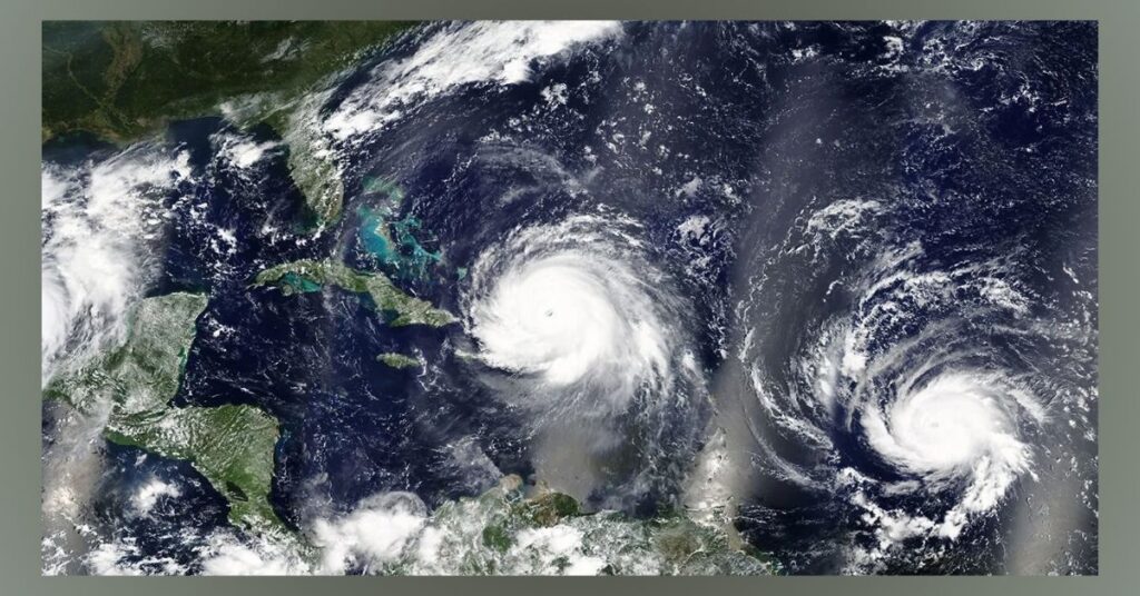
Sea Surface Temperatures (SSTs)
Warm sea surface temperatures (SSTs) play a pivotal role in the formation and intensification of hurricanes, particularly around Puerto Rico during the peak hurricane season from August to October. With SSTs frequently exceeding 26.5°C (approximately 80°F), these waters create a ripe environment for cyclone development, harnessing energy from the ocean that fuels storm systems to reach unprecedented strengths.
This geographical phenomenon not only amplifies the frequency of hurricanes but also raises concerns about their unpredictability, as climate change continues to warm oceanic waters and exacerbate these natural disasters.
Atmospheric Conditions
For hurricanes to form and sustain in Puerto Rico, a unique set of atmospheric conditions must be met. These include a moist lower to middle atmosphere conducive to the accumulation of heat and moisture, along with low wind shear, which avoids disrupting storm systems.
High humidity levels during hurricane season often lead to the development of thunderstorms crucial building blocks for hurricanes. The Intertropical Convergence Zone (ITCZ), typically positioned near the region, plays a significant role by providing lift and instability that fuels potential storms.
Prevailing Wind Patterns
The prevailing wind patterns, notably the easterly trade winds and steering currents in the upper atmosphere, critically shape the hurricane trajectories that often impact Puerto Rico. These winds typically flow from east to west across the Atlantic, guiding storms as they develop near Africa or in the eastern Atlantic.
A key player in this dynamic is the Bermuda High, a prominent high-pressure system that not only dictates storm movement but also their intensity and speed. When this system strengthens, it can steer hurricanes directly towards Puerto Rico, increasing cyclone frequency during certain tumultuous seasons.
Puerto Rico’s Geographical Location
Nestled at the eastern extremity of the Caribbean basin, Puerto Rico finds itself in a unique geographical dance with nature. Its position means that it often serves as an initial line of defense against the fury of storms birthing in the Atlantic.
As these cyclonic systems gather strength over warm Caribbean waters, they can transform into powerful hurricanes that make their way towards this vibrant island. This natural reality not only shapes Puerto Rico’s weather patterns but also influences its culture and community resilience.
Technological Advances in Hurricane Tracking and Forecasting
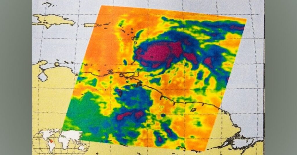
The advent of satellite imaging has revolutionized hurricane monitoring, enabling meteorologists to access near-real-time data from space. Advanced satellites provide detailed imagery of storm systems, allowing scientists to observe their formation and evolution with unprecedented clarity.
This visual data enhances forecasting models, as algorithms can analyze the satellite images alongside historical climate patterns, improving predictions for a storm’s intensity and trajectory.
Satellite Imaging
Satellite imaging represents a revolutionary advancement in the way meteorologists track and forecast hurricanes. Modern satellites are equipped with state-of-the-art sensors that can capture intricate details about atmospheric conditions and surface features.
These powerful tools allow for the detection of subtle changes in temperature, humidity, and cloud formations critical elements that signal hurricane development. By providing real-time data, satellite imagery enables scientists to not only monitor storm progress but also analyze intensity fluctuations and predict potential impact paths, ensuring that alerts reach affected regions with maximum efficacy.
Computer Modeling
Computer modeling has revolutionized how meteorologists predict hurricanes, turning what was once a guessing game into a precise science. By employing complex algorithms that simulate the Earth’s atmosphere, these models consider variables like air movement, temperature fluctuations, and moisture levels to create highly detailed forecasts.
The incorporation of real-time data from satellite imagery and ground-based meteorological stations allows these models to continuously refine their predictions.
As computational power has increased over the years, so has the precision of these simulations, today’s models are better than ever at forecasting not only where a hurricane will make landfall but also its potential intensity and impact.
As I walked through the sunny streets of Cartagena, a colorful and lively city, I wondered: Is Cartagena Colombia safe?
Impact of Technology on Public Safety and Preparedness
In recent years, technological advances in hurricane tracking and forecasting have revolutionized how we respond to these powerful storms. The accuracy of predictions has dramatically improved, allowing meteorologists to anticipate a hurricane’s path with remarkable precision.
This elevated level of forewarning not only affords individuals the opportunity to safely evacuate but also empowers businesses and homeowners to take proactive measures in safeguarding their properties.
With sophisticated models that simulate atmospheric conditions, people can now access real-time updates on storm developments via mobile apps and social media platforms, further enhancing community awareness and engagement.
Nurturing Hope and Security
As we brace ourselves for the unpredictability of hurricane seasons, advancements in technology have transformed how we approach these atmospheric giants. Modern meteorology employs sophisticated satellite imagery, radar systems, and computer modeling to enhance hurricane tracking and forecasting accuracy.
This innovation allows communities like those in Puerto Rico to receive timely information, enabling residents and local governments to make informed decisions about evacuation routes or shelter locations. The rise of social media as an immediate communication tool further bridges the gap between agencies and the public, fostering a collective sense of preparedness.
Conclusion
The hurricane season in Puerto Rico serves as a powerful reminder of the island’s vulnerability to nature’s fury. With rising sea temperatures and changing weather patterns, residents must remain vigilant and prepared for potential storms. Community awareness and proactive measures can significantly mitigate the impacts of hurricanes on families and infrastructure.
By staying informed about emergency protocols and participating in local preparedness initiatives, individuals can contribute to a stronger, more resilient Puerto Rico. As hurricane season approaches, let us all commit to prioritizing safety and readiness for ourselves and our neighbors.
FAQs
What should I do if a hurricane warning is issued while I’m in Puerto Rico?
Follow local authorities’ instructions, seek shelter in a designated area, and ensure you have essentials like food, water, and medications.
Are there any insurance considerations for homeowners in Puerto Rico during hurricane season?
Homeowners should review their insurance policies to ensure they have adequate coverage for wind and flood damage caused by hurricanes.


